Equinor Norpipe Nearshore Pipeline Inspection Survey Project
- 2019-09-02
- By admin
- Posted in Pipeline inspection
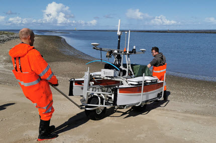
Contracted by 4D Ocean to provide a ASV Hydrographic Surveyor for the Equinor Norpipe Nearshore Pipeline Inspection Survey project. With a landfall in Greetseil, Germany, the very shallow bathymetry presents a number of problems for traditional pipeline inspection platforms. Instead, surveys were conducted at high water using 4D Ocean’s ASV Harry, a SeaRobotics 2.5m unmanned surface vehicle with an integrated Applanix POS MV and R2Sonic 2020 multibeam echosounder. Transported by road trailer, the deployment cart allows access to remote or inaccessible locations.
Topographic surveys were conducted at low water using 4D Ocean’s eBee UAV, a fully autonomous drone, which is used to capture high-resolution aerial photos that can be transformed into accurate orthomosaics and 3D models using photogrammetric techniques.
Recent Posts
- BP Caspian Shallow Water Pipeline Inspection Survey 13/01/2020
- Equinor Nearshore Pipeline Inspection Survey Project 23/10/2019
- SSEN Pentland Firth HVAC Survey Project 14/09/2019
- Equinor Norpipe Nearshore Pipeline Inspection Survey Project 02/09/2019
- 4D Ocean Linne Crowlin and Loch Carron Survey 22/07/2019
Recent Comments
- admin on Marin Mätteknik Culver Sands to Flat Holm Survey
- martin sharp on Marin Mätteknik Culver Sands to Flat Holm Survey
- admin on Marin Mätteknik Culver Sands to Flat Holm Survey
- Arien Kampman on Marin Mätteknik Culver Sands to Flat Holm Survey
- Fred Colebrooke on Marin Mätteknik Lyme Bay – Natural England Survey
Archives
Categories
- Archaeology (3)
- Hydrographic survey (35)
- Other (12)
- Pipeline construction (11)
- Pipeline inspection (14)
- Renewables (8)
- Route survey (10)
- Topographic survey (1)
- UXO survey (6)