Sub-contracted through NetSurvey to provide Marin Mätteknik AB with a Reports Coordinator for the MCA Culver Sands to Flat Holm Survey. Conducted as part of the Civil Hydrography Programme, the 97 square kilometre survey area covers a section of the Bristol Channel, extending from Culver Sand in the south-west to Flat Holm and Lavernock Point in the north-east. The seabed topography is extremely complex – sandy, muddy and gravely areas have been identified, as well as rock outcrops and sand waves. Numerous wrecks were known to exist within the survey area, however, eight new significant contacts were also found. MMT’s specialised shallow water survey vessel, MV Seabeam, was used to acquire Kongsberg EM3002 dual-head multibeam data. Caris HIPS and Fledermaus were utilised to verify the data, with a Report of Survey submitted to the UK Hydrographic Office, along with high-resolution FM Geocoder backscatter data and seabed samples to support seabed classification.
4 thoughts on “Marin Mätteknik Culver Sands to Flat Holm Survey”
Is the wreck Diana . Position 51.18NB and 3.10WL NNE of Culver Sands involved in any operation?
At 18 januari 1941 my uncle was captain on this ship when is sank after blown up by a mine. If there is anybody who can provide information. Please contact Arien Kampman. Leeuwarden. The Netherlands. Thank you.
Hi Arien. Thank you for your comment. I believe that the location of the ‘Diana’ plots about a mile to the south of the survey area, which is a shame, as we might have been able to find some imagery of it. It is always fascinating to hear the stories of all of these wrecks around our coastline. Good luck with finding out more information. Best Regards. Mark.
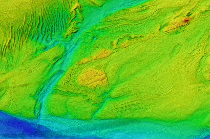
That is an amazing view of the channel , i have looked at the Bristol Port Company charts when i get to work on their survey vessel now and again and after spending all my life working in the Bristol Channel im still amazed at how i thought the seabed would look compared to how it actually is especially the sand banks as i used to work on a sand dredger and we would often bring up parts of wrecks or old 19c ships anchors i even have a silver william the lll 1697 silver penny that we sucked up off the west one fathom bank i often wounder what history is behind it as only 2 ships sank that could have carried that coin before the new minted coins with a queen in 1702 . I recreational fish from my own boat and find these charts a massive source of information when it comes to picking new marks for fishing. Will these survey charts become available to the public to buy at some point? i am so fascinated with the upper Severn and mid Bristol Channel i would love to get my hands on one as i have one for the area i fish around the Bristol Deep . i am also amazed when you put a survey chart next to a traditional paper chart and all those depth lines become real and how accurate they are!! i use the chart i have for finding mason worm reefs
martin ..upper reaches of the bristol channel
Hi Martin,
Thanks for your comments. Yes, it is quick a spectacular view of the seabed isn’t it! All of the data is used to update the traditional UKHO paper charts, but I believe that they have now made some of the datasets available to the public too. You can certainly download images of the data for use in Google Earth. Some further information on this is available on the following link:
https://www.gov.uk/guidance/share-hydrographic-data-with-maritime-and-coastguard-agency-mca
Regards
Mark